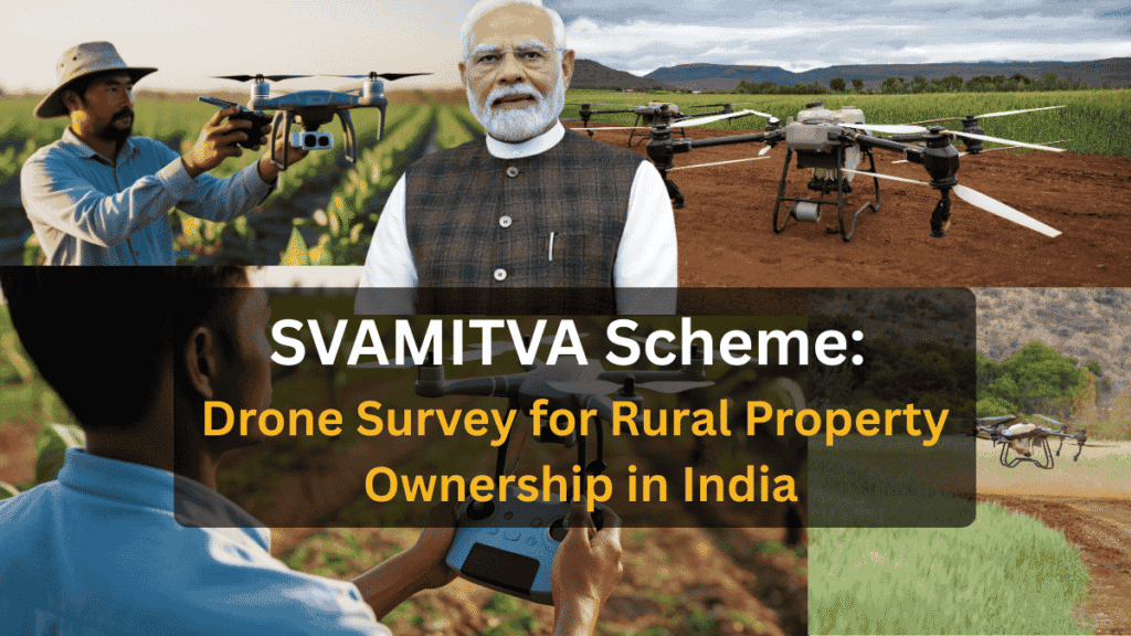
SVAMITVA Scheme (Survey of Villages and Mapping with Improvised Technology in Village Areas) is a flagship initiative of the Government of India aimed at providing legal ownership of rural residential properties using drone technology. Launched to empower villagers, the scheme helps resolve land disputes, enable bank loans and improve rural planning.
In this article, we explain what the SVAMITVA Scheme is, how drones are used, its benefits, eligibility and how villagers can access their property cards.
🧾 What is the SVAMITVA Scheme?
SVAMITVA (full form: Survey of Villages and Mapping with Improvised Technology in Village Areas) is a Central Sector Scheme launched by Prime Minister Narendra Modi on National Panchayati Raj Day (April 24, 2020), with nationwide rollout in 2021 after a successful pilot in 9 states.
- Nodal Ministry: Ministry of Panchayati Raj.
- Key Partners: State Revenue/Panchayati Raj Departments, Survey of India (for drone surveys), and National Informatics Centre (for tech support).
- Core Focus: Only on rural abadi (inhabited/residential) areas—not agricultural land or urban properties. It aims to give villagers formal “Record of Rights” for their homestead land, which was often undocumented or based on outdated records, leading to disputes and inability to use property as collateral.
The scheme has been extended till FY 2025-26 for universal coverage across India’s ~6.6 lakh villages.
🎯 Objectives of the SVAMITVA Scheme – Explained
1️⃣ Provide legal ownership records to rural households
For decades, many villagers lived on their ancestral land without any official ownership documents. The SVAMITVA Scheme aims to issue Property Cards that legally recognize who owns which house or plot in the village abadi area. This gives rural families formal proof of ownership, similar to urban property records, and ensures their rights are protected.
2️⃣ Reduce land and property disputes
Unclear boundaries and lack of records often lead to disputes between neighbours or families. By using drone surveys to map exact property boundaries, SVAMITVA creates transparent and accurate records. This helps prevent conflicts, reduces court cases, and brings long-term peace and clarity in villages.
3️⃣ Enable villagers to use property as financial assets
Without legal documents, villagers cannot use their homes as collateral for loans. With Property Cards issued under SVAMITVA, homeowners can approach banks and financial institutions to:
- Get loans
- Access credit for farming or small businesses
- Improve houses or start enterprises
This promotes financial inclusion and rural entrepreneurship.
4️⃣ Support village-level planning and development
Accurate maps and property data help Panchayats and local authorities plan better infrastructure such as:
- Roads and drainage
- Water and sanitation
- Electricity and internet
- Schools and health centers
With clear land records, development projects can be executed faster and more efficiently.
5️⃣ Create accurate land records using drone technology
Traditional land surveys are slow and often outdated. SVAMITVA uses high-resolution drones and GIS technology to:
- Capture precise images of villages
- Prepare digital maps quickly
- Maintain up-to-date records
This ensures accuracy, transparency, and modernization of land administration in rural India.
🚁 Role of Drones in SVAMITVA – Explained in Detail
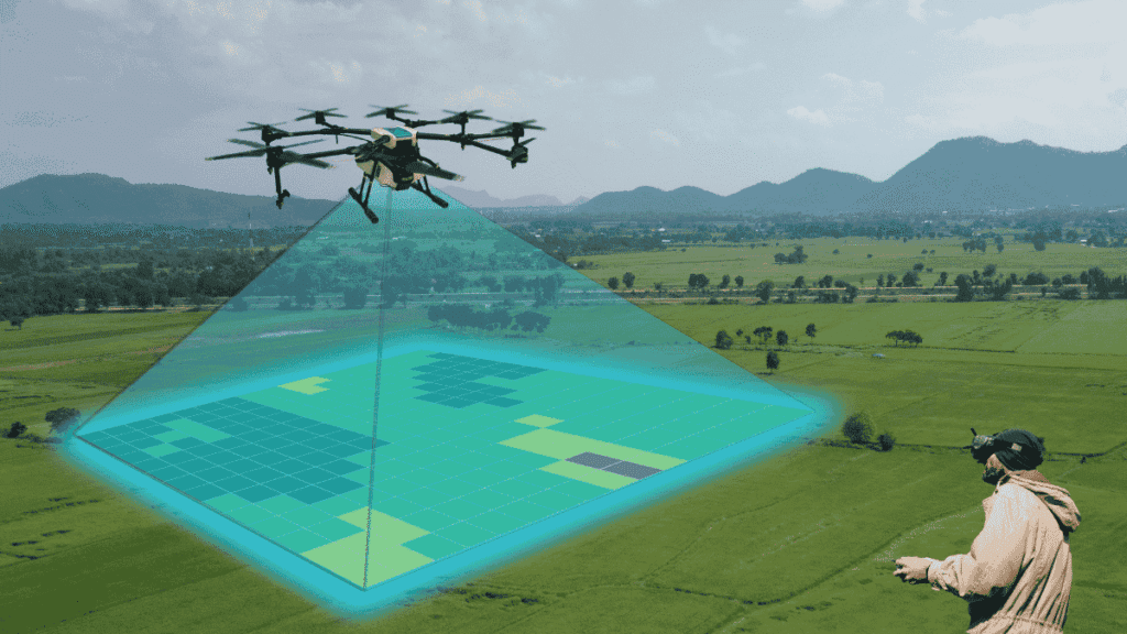
Under the SVAMITVA Scheme, drone technology plays a central role in modernizing how rural land records are created and maintained. Instead of relying on slow and manual ground surveys, high-tech drones are used to map village abadi areas with speed and precision.
📸 Capture high-resolution images of village abadi areas
Drones fly over villages and take extremely detailed aerial photographs of houses, streets, and plots. These images clearly show rooftops, boundaries, and layouts, even in densely populated areas. The high resolution ensures that no structure is missed and every property is visible.
🗺️ Create precise digital maps
The aerial images are processed using GIS and photogrammetry software to generate accurate digital village maps. These maps show the exact location, size, and shape of each property. The result is a modern, geo-referenced map that can be stored and updated digitally.
📐 Mark property boundaries accurately
Using the drone data, survey teams mark the boundaries of individual houses and plots. These boundaries are verified on the ground with villagers and local officials to resolve overlaps or objections. This ensures that each owner’s area is correctly identified before issuing Property Cards.
🔗 Integrate data with land records
The digital maps are then linked with existing state land record systems. Each mapped property is assigned an owner’s name and unique ID, forming a reliable Record of Rights. This integration helps maintain consistency between maps and official databases.
⚡ Faster, transparent, and more accurate than traditional surveys
Traditional surveys can take months or even years and may involve manual measurements prone to errors. Drone surveys:
- Cover entire villages in hours or days
- Minimize human error
- Provide visual evidence for transparency
- Enable quick updates when changes occur
As a result, the process becomes quicker, fairer, and far more reliable, helping both villagers and authorities trust the system.
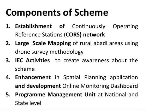
🏡 Key Features of SVAMITVA Scheme
- Drone-based mapping of villages
- Issuance of Property Cards (Record of Rights)
- Digital village maps and GIS data
- Coverage of lakhs of villages across India
- Integration with state land record systems
✅ Benefits of SVAMITVA Scheme
For Villagers:
- Legal proof of property ownership
- Easier access to bank loans & credit
- Reduced disputes among neighbours
- Increased property value and security
For Government:
- Better tax assessment
- Improved rural planning
- Accurate land databases
- Support in disaster management
👥 Who is Eligible?
- Residents owning houses in village abadi areas
- Properties covered under drone survey in notified villages
- Eligibility and process may vary slightly by state
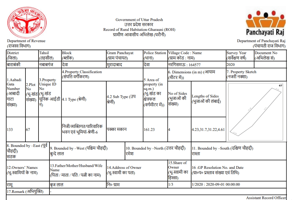
📝 How Property Cards are Issued under the SVAMITVA Scheme
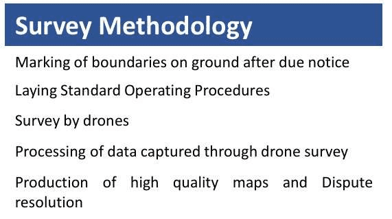
The issuance of Property Cards under the SVAMITVA Scheme follows a transparent, step-by-step process to ensure accuracy and fairness for every household in the village.
🚁 1️⃣ Drone survey of village abadi area
First, trained teams conduct a drone survey of the village’s abadi (inhabited) area. Drones capture high-resolution aerial images of houses, streets, and plots. This forms the base data for mapping property boundaries accurately.
🗺️ 2️⃣ Draft maps prepared and displayed in the village
Using drone images, authorities prepare draft property maps showing individual plots and their tentative boundaries. These maps are then displayed publicly in the village Panchayat office or common areas so that residents can view their property details.
🗣️ 3️⃣ Objections invited and resolved
Villagers are invited to check the draft maps and raise objections if:
- Boundaries are incorrect
- Ownership details are wrong
- Any property is missing or overlapping
Officials conduct field verification and discussions with concerned parties to resolve disputes. This step ensures community participation and accuracy.
✅ 4️⃣ Final maps approved
After all objections are addressed, the corrected maps are finalized and approved by the competent state authorities. These become the official digital records for the village abadi area.
🏠 5️⃣ Property Cards distributed to owners
Based on the final maps, Property Cards (Record of Rights) are generated for each property owner. These cards include:
- Owner’s name
- Property ID
- Area and boundaries
- Map reference
They are distributed through Panchayats or special camps and serve as legal proof of ownership.
🌐 6️⃣ Online access through land record portals
In many states, property details are also uploaded to official land record portals. Villagers can:
- View or download their Property Cards online
- Verify ownership details
- Use them for bank loans or official purposes
This adds convenience and transparency to the system.
This process ensures that Property Cards are accurate, community-verified, legally valid, and digitally accessible, making SVAMITVA a trusted reform in rural land governance.
🌍 Implementation Status
The scheme is being implemented across multiple states and UTs in phases. Many villages have already received property cards, and the government continues to expand coverage nationwide.
📈 Impact of SVAMITVA Scheme
- Strengthened rural property rights
- Financial inclusion for villagers
- Increased transparency in land administration
- Use of modern technology in governance
The scheme is transforming how rural land ownership is recorded in India.
❓Frequently Asked Questions (FAQs)
Q1. What is the main purpose of the SVAMITVA Scheme?
Ans- To provide legal ownership of residential properties in rural areas using drone mapping.
Q2. Is SVAMITVA applicable in urban areas?
Ans- No, it mainly focuses on village abadi (inhabited) areas.
Q3. Are Property Cards legally valid?
Ans- Yes, they serve as legal proof of ownership as recognized by state governments.
Q4. How can villagers get their Property Card?
Ans- Through local Panchayat or state land record portals after survey completion.
Q5. Is there any cost to villagers?
Ans- Generally, no. The survey and card issuance are funded by the government.
🏁 Conclusion
The SVAMITVA Scheme marks a transformative shift in how rural land ownership is recorded and managed in India. By combining cutting-edge drone technology with transparent land governance, the scheme addresses a long-standing gap in rural property rights. For millions of villagers who lived without formal documents for generations, Property Cards bring legal identity, dignity, and security to their homes.
Beyond ownership, SVAMITVA opens the door to financial empowerment. With valid property records, rural households can access bank loans, start small businesses, invest in agriculture, and improve their living conditions. This helps integrate villages into the formal economy and strengthens financial inclusion at the grassroots level.
The scheme also supports planned rural development. Accurate digital maps enable Panchayats and governments to design better infrastructure, manage resources efficiently, and implement welfare schemes more effectively. At the same time, clearly defined boundaries reduce disputes, saving time, money, and social conflict within communities.
If implemented and updated consistently across states, SVAMITVA has the potential to become a backbone of rural transformation in India. It not only modernizes land records but also empowers citizens, improves governance, and builds a strong foundation for inclusive growth. In the long run, SVAMITVA can play a key role in shaping a more secure, prosperous, and digitally connected rural India.
Have you or your village received Property Cards under SVAMITVA?
Share your experience in the comments and explore our guide on other Government Drone Schemes in India.
Also Read : NaMo Drone Didi Scheme: Empowering Rural Women Through Drone Technology